 Fernflieger.de
 Fernflieger.de
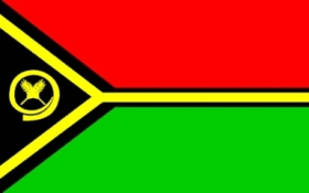
| Flagge: |  |
| Kontinent: | Australien und Ozeanien |
| Ländercode: | VU |
| Bevölkerung: | 270.000 |
| Fläche: | 12.200 km² |
| Bevölkerungsdichte: | 22 Einwohner pro km² |
| Hauptstadt: | Port Vila |
| Regierungssitz: | wie Hauptstadt |
AUY – Aneityum Airport, Anatom Island, VU-TAE, VU
AWD – Aniwa Airport, Aniwa, VU-TAE, VU
CCV – Craig Cove Airport, Craig Cove, VU-MAP, VU
DLY – Dillon's Bay Airport, Dillon's Bay, VU-TAE, VU
EAE – Siwo Airport, Emae Island, VU-SEE, VU
FTA – Futuna Airport, Futuna Island, VU-TAE, VU
IPA – Ipota Airport, Ipota, VU-TAE, VU
LNB – Lamen Bay Airport, Lamen Bay, VU-SEE, VU
LNE – Lonorore Airport, Lonorore, VU-PAM, VU
LOD – Longana Airport, Longana, VU-PAM, VU
LPM – Lamap Airport, Lamap, VU-MAP, VU
MTV – Mota Lava Airport, Ablow, VU-TOB, VU
MWF – Maewo-Naone Airport, Maewo Island, VU-PAM, VU
NUS – Norsup Airport, Norsup, VU-MAP, VU
OLJ – North West Santo Airport, Olpoi, VU-SAM, VU
PBJ – Tavie Airport, Paama Island, VU-MAP, VU
RCL – Redcliffe Airport, Redcliffe, VU-PAM, VU
SLH – Sola Airport, Sola, VU-TOB, VU
SON – Santo Pekoa International Airport, Luganville, VU-SAM, VU
SSR – Sara Airport, Pentecost Island, VU-PAM, VU
SWJ – Southwest Bay Airport, Malekula Island, VU-MAP, VU
TAH – Tanna Airport, VU-TAE, VU
TGH – Tongoa Airport, Tongoa Island, VU-SEE, VU
TOH – Torres Airstrip, Loh/Linua, VU-TOB, VU
UIQ – Quion Hill Airport, Quion Hill, VU-SEE, VU
ULB – Uléi Airport, Ambryn Island, VU-MAP, VU
VLI – Bauerfield International Airport, Port Vila, VU-SEE, VU
VLS – Valesdir Airport, Epi Island, VU-SEE, VU
WLH – Walaha Airport, Walaha, VU-PAM, VU
ZGU – Gaua Island Airport, Gaua Island, VU-TOB, VU
Seite: 1
Die Daten der Länder wurden mit Sorgfalt recherchiert. Der Datenstand wie beispielsweise die Einwohner des Landes oder die Bevölkerungsdichte entsprechen dem Jahr 2015.
Alle Angaben ohne Gewähr.